|
|
 |
|
|
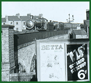
GWR Route: Stratford on Avon to Honeybourne
Sancta Lane Station: gwrsanct3162
A 1939 Ordnance Survey map showing the junction and
connecting line from Sanctus Road to the East & West Junction station. The
former SMJ carriage and wagon sidings can be seen running parallel to the SMJ
line to Broom whist the station and shed is on the right. The exchange line was
double track as it passed the SMJ goods yard and warehouses. The GWR entitled
their station 'Stratford-on-Avon whereas the SMJ/MR/LMS used
Stratford-upon-Avon, this different usage is still found today vis-a-vis
Stratford-on-Avon District Council and Stratford-upon-Avon Town Council.
 back back
|
|
|