|
|
The North Warwickshire Line
Strictly speaking the Birmingham, North Warwickshire and
Stratford-upon-Avon Railway¹, to
give the line its correct title, runs from Tyseley to Bearley North Junction.
However, in the spirit of the Great Western Railway, who built the line as part
of a new route to the West of England, we have included stations both north of
Tyseley to Snow Hill and south of Bearley North Junction to Pebworth - which
was the last station within Warwickshire - to provide a coherent route. This
reflects the reality that the route from Snow Hill or Moor Street to Pebworth
and beyond was in fact made up of four routes built by different companies over
a period of fifty-five years.
From Snow Hill a passenger would travel to Tyseley on the
Birmingham and Oxford Railway's mainline then at Tyseley their train
would be carried over the Birmingham, North Warwickshire and
Stratford-upon-Avon Railway's line to Bearley North Junction where it would
join the Stratford Railway Company's branch from Hatton to Stratford
upon Avon and finally from Stratford-on-Avon they would travel south on the
former branch of the Oxford, Worcester & Wolverhampton Railway's to
Honeybourne now upgraded with doubled track. As with many other railway
initiatives the origins of the Birmingham and North Warwickshire Railway
lay with local landowners and merchants seeking to provide a route that would
provide benefit to their commercial interests. Originally it was conceived as
being a route from a new terminus to be built at Moor Street to Stratford upon
Avon from where it would have running rights to traverse over the GWR's line to
Honeybourne.
Robert Ferris has been researching the route and has
unearthed the following contemporary articles. For information on the West of
England route through Warwickshire see the article on 'The North Warwickshire
Line' by Harold D Smith first printed in the Great Western Railway Magazine in
January 1908 and the 'Doubling of the Stratford-on-Avon Branch' by G H
Mackillop again from the Great Western Railway Magazine but their April 1908
edition. In addition, the GWR, as with all the railway companies, extensively
promoted places to visit by their railway services and Stratford upon Avon and
other areas within Warwickshire were no exception. Robert Ferris has
transcribed some extracts from contemporary GWR books and these can be read by
visiting the link to the GWR Publicity page below.
Use the links below to access the
following sections on this page.
back to
top
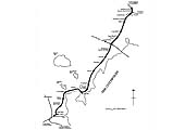
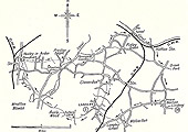
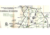
Route Map: North Warwickshire Railway
Route commences at Honeybourne
The History of the Birmingham and North Warwickshire
Railway
by Harold D Smith
back to
top
The importance of the Birmingham and North Warwickshire
Railway¹ lies mainly in the fact that
it is the final link in the Great Western short route between Bristol and
Birmingham, via Gloucester, Honeybourne and Stratford. Formerly those who
elected to travel by the Great Western Railway between those points had to make
a long detour via the Severn Tunnel, Hereford, Worcester, Kidderminster, a
distance of 133 miles over a steeply graded route or travel via Didcot and
Banbury, a distance of 141 miles. By means of the new connection between
Tyseley and Bearley and between Honeybourne and Cheltenham, together with a
revival of the running powers over the Midland line from Standish to Yate, the
Great Western Company will possess a route of only 95 miles in length, with
gradients and curves suitable for express services.
The total length of the new line from Tyseley to Bearley
West Junction is Seventeen and three quarter miles. There is also a loop
connecting the old Lapworth and Henley-in-Arden branch with a new station at
the latter place. The name ‘Birmingham and North Warwickshire
Railway’ scarcely conveys an accurate idea of the position of the new
line. Leaving the main line to Paddington at Tyseley station three miles south
east of Birmingham, it terminates at a junction with the Hatton and Stratford
line, about half a mile from Bearley station. Its course is roughly north and
south, and it skirts the eastern boundary of Warwickshire, occasionally
crossing into Worcestershire. The only apparent justification for the word
‘north’ is that it cuts through the country of the North Warwickshire
Hunt.
A more descriptive name would be the ‘Arden
Railway’, for the Forest of Arden is responsible for the names of five out
of the eight stations on the line. Yardley Wood, Earlswood, Wood End, and
Henley-in-Arden are obvious enough; Wootton Wawen is a little abstruse, but
nevertheless is associated with the forest, which covered the whole of
Warwickshire, filling the angle between the Severn and the Avon as far north as
Wolverhampton. The inhabitants until the eighteenth century depended for corn
on the ‘Feddon’, the land lying south of the Avon. However the demand
for charcoal for iron smelting cleared the wood, and the land coming under the
plough was found to be so productive as to outrival the Feddon district. Much
of it is now pasture, and a heavy milk traffic is likely to develop.
Geologically the line is cut on the outcrop of the Keuper or
Upper Trias. The first cutting after leaving Tyseley is almost entirely in
loamy gravel, but the marl is reached just above rail level. Passing south the
thickness of gravel generally decreases and it is altogether absent in some
cuttings, but a good gravel site may be found for building at almost any spot
on the line. This marl is a most excellent material for railway making. In the
cutting at Wood End, at the bottom of a slope 40 feet long, a vertical face
stood perfectly through the winter, and the embankments of marl have stood
without giving signs of slips. It will stand at almost any angle without
timber, and the absence of anything like a failure in foundations throughout
the work is an excellent proof of its stability.
From Tyseley the line follows the valley of the River Cole
to Wood End where it passes through a short tunnel and gains the valley of the
Alne, a tributary of the Avon which it does not again leave. The high ground at
Wood End contains the sources of both river, and forms the water shed of
England. Incidentally, the tunnel diverts the rainfall of a very small area
from the Humber to the Bristol Channel. Floods rise with great rapidity both in
the Cole and the Alne, and a few years since a bridge with a total waterway 73
feet wide was washed away by the Alne at a place only 10 miles from its source
where it can usually be easily forded. The custom of the country is to carry
all roads over streams on bridges which will only take the average flow, and to
depress the road level at each side of the bridge so that floods may pass over
the roads. A length of a quarter-of-a-mile of road is often under water. River
bridges, culverts, and stream diversions have therefore been provided on an
unusually large scale.
In laying out a railway it is of the highest importance to
keep the gradients as flat as possible. A moderate curve does not add
appreciably to the tractive force required, but the weight of a possible train
for a given engine is limited by the steepest gradient on the line. A rise in a
railway causes the motive power to do work against gravity in raising the load
bodily, whereas on a curve the resistance to traction is only that due to the
friction of deflecting the load horizontally. At Tyseley rail level is 400 feet
above sea level. Thence it rises for 2 miles 15 chains, and after falling only
4 feet on a gradient of 1 in 500, it rises consistently to the summit of 500
feet at Earlswood Lakes station, 6 miles 57 chains from the commencement. The
gradients against the load in this direction, with one exception, are not
steeper than 1 in 183.
After leaving Earlswood Lakes station the line falls at 1
in 180 for one and a half miles, and then acquires an uniform gradient of 1 in
150, which, modified by Board of trade requirements through stations, is
maintain for eight miles. At 16 miles 4 chains rail level has fallen to 200
feet above sea level, which it retains for nearly half a mile before rising
slightly, passing under the aqueduct of the Birmingham and Stratford Canal, and
joining the Alcester branch at 17 miles 13 chains. From this junction the
Alcester line is widened, and the branch forms part of the new line. They
separate again at 17 miles 24 chains and, rising at 1 in 462, the new line
terminates at 17 miles 69 chains at a junction with the Stratford line.
The starting and finishing points of the line are fixed by
the levels of the existing rails at the junctions. Another tie point is the
level of the ground at Earlswood and Wood End. To have lowered the rail level
here by a few feet would have increased the cost of the line enormously; for
the contents of a cutting through a summit increases roughly as the cube of the
depth of that cutting and Wood End cutting is already nearly 60 feet deep.
Having fixed on the sum that could economically be expended in cutting in this
neighbourhood, the next point in locating the line was to get as far as
possible an uniform gradient from either end, to the summit. The longitudinal
section shows how nearly this has been accomplished. Having determined the
ideal gradient, the next step was to fix the line on the map in such a way that
the ground level should coincide therewith. In almost any country such a line
may be laid down, but it will not be a practical one, as it will consist of
irregular curves round shoulders of hills and sharp angles where it crosses
valleys.
The best plan, if practicable without departing too far
from the ideal gradient would be a straight line from point to point. At a
conference of ministers and engineers engaged in discussing the course a State
railway should take between two towns, a Russian Sovereign is said to have
drawn his sword and laid it across the map, thus settling, to his own
satisfaction, the whole affair. He failed, however, to see that practical
gradients suitable to the contour of the country were more important to the
location of the line than straightness on the map. Between the ideal straight
line and the irregular contour line marked by the ideal gradient on the map,
lies the best practical position. It is obtained by cutting into the shoulder
of the hills, and forming embankments across valleys, and how far the final
line shall depart from the straight direct line is mostly a question of
cost.
In a flat uninteresting country the course of the line would
be more direct. The sinuous course of the line is due to the pleasing rolling
nature of the country, for deviation from the direct course indicates a hill of
valley to be avoided. In the case of the Birmingham and North Warwickshire
Railway there is – with the exception of a short length leaving the main
line at Tyseley - no curve of less radius than half a mile. Out of a total
length of 17 miles 69 chains, 7 miles 69 chains is straight, and the average
radius of the remaining 10 miles is fifty five and a half chains. The total
curvature of the whole line is 14’37 radians, which means that if all the
curves were in the same direction and the lengths of straight were omitted, the
line would describe a complete circle twice with a right angle to spare. The
amount of curvature per mile of the total length of the railway is ‘804
radians. This would be a useful figure in comparing one line with another, and
might for convenience be called the ‘sinuosity’ of a railway.
The total excavation of the cuttings measures 1,500,000
cubic yards, and is distributed over a length of eight and three quarter miles
of cuttings having an average capacity of 2,130 cubic yards per chain of
length. In a line of this character, passing through a country district,
excavation is the main factor controlling the speed at which the work can be
completed. The most favourable distribution of excavation for rapid
construction is that the cuttings should be short, and should alternate with
embankments capable of absorbing the earth excavated in each cutting. On this
railway the cuttings were distributed in such a way as to put two obstacles in
the way of rapid completion. The first of these is the commencement of the
railway, where 264,000 cubic yards had to be excavated from a continuous
cutting a mile and three quarters long, and all had to be conveyed through the
south end of the cutting. A steam navvy commenced excavation in February 1906,
and it was practically finished in the first week of Just last.
The average rate was 3,700 cubic yards a week, but the work
was somewhat hampered by the failure of a gravel embankment 30 feet high,
between 3 miles 20 chains and 3 miles 40 chains, where the excavation was being
tipped. The embankment was tipped in two lifts. The first was 14 feet high, and
was formed of the loamy gravel from the Tyseley cutting. When excavated this
gravel was full of water and very unstable, but after being jolted inn the
wagons, drained in the embankment, and consolidated by contractor’s
traffic for fifteen months, it appeared to form a very substantial bank and
everyone was surprised when it gave way. The top lift of the embankment was
partly formed of the same loamy wet gravel, until it was found the bottom lift
would not bear the weight of similar material to itself. As soon as the top
lift approached full width the bottom gave, the earth being squeezed outwards
between the top lift and the original surface of the ground. The ground on
which the embankment rests is good solid gravel, and has stood perfectly
without contributing in any way to the slips which have taken place.
The remedy was fairly obvious, No more heavy wet material
was tipped, the remainder of the top lift was formed of light ashes, and the
bottom was kept in place by a layer of heavy slag distributed over its slopes.
The second obstacle was the tunnel and its cuttings at Wood End. The former is
as usual, approached by two deep cuttings, and one of these had to be excavated
before access on a low level could be had to the tunnel itself. 214,000 cubic
yards of excavation lying to the north of the tunnel had to be conveyed to
embankments south of it, and to avoid the costly and slow process of hauling
over the summit of the hill an attempt was made to get the tunnel finished
before starting the excavation at the north end. The cutting south of the
tunnel contains 107,000 cubic yards. It was started on January 9th, 1906, and
by April 12th 86,300 cubic yards had been dug out and the end of the tunnel
could be got at.
The tunnel is 175 yards long: a commencement was made
excavating for the south end on April15th 1906, and the last brick was put into
the arch on November 22nd 1906, the work advancing at the rate of six and a
half yards per week. In August 1906, the air at the north end of the heading
was foul from the use of explosives, and for ventilation a hole was cut to the
surface. A man started in the evening, and by the morning had worked his way
through 40 feet of marl above him, and reached the air. A week later the air
shaft proved most useful, for the roof of the heading fell in, and but for the
air hole the men must have been imprisoned.
A few years ago there was a discussion in the papers as to
the number of bricks a man should lay in a day, and a case was cited of a man
who had laid 300 bricks, presumably in architectural work when each brick has
to be most correctly laid. The tunnel was done in lengths of 15 feet, each
length absorbing nearly 40,000 bricks. Four men laid this number of bricks in
two shifts, each shift occupying a day and a night at least and sometimes as
long as a day and two nights. The two shifts on the average occupied sixty
hours and during that time each man would lay 10,000 bricks, equivalent to
2,000 in a day of twelve hours. Eleven steam navvies and twenty three
locomotives were employed on the line. There are sixty four bridges, twenty of
which are met with on the first five miles from Tyseley. The number is made up
as follows:-
- Public road bridges - 29
- River and canal bridges - 7
- Accommodation road bridges - 19
- Accommodation river bridges - 9
As with the earthworks, the bulk of the bridgework was done
in the fine weather, between April and October last year. The bridges generally
are of the usual types, in blue brick, but the most expensive of all is,
strangely enough, an accommodation bridge. It carried the railway over a
disused drive leading towards a fine old house, built of local stone from
quarries which have since been worked out and closed. When the line was
proposed the stipulation was made that it should cross the drive on three
elliptical arches of stone obtained from Derbyshire of colour to match the
house. This affords little idea of the difficulties encountered in designing
and building it. All arches which are segments of a circle on a line square to
the abutments show an elliptical curve on the face when built on the skew, but
this arch although built on the skew had to be elliptical on a line square to
the abutments.
In a skew bridge of which the span is anything considerable
the voussoirs have to be laid as nearly possible square to the face line. A
ruled sheet of paper rolled obliquely over a ruler gives a good idea of the
courses on a segmental skew arch. All these corners are curved lines, and the
joints between the ends of the adjacent voussoirs themselves are curved. Even
the joints of the voussoirs where cut by the skew face are curved. The curves
are spirals or functions of spirals based on the circle and have all been
investigated and reduced to rule. On an elliptical skew arch all this is
changed, for the radius of the arch itself changes continually from a maximum
at the crown to a minimum at the springing. The result is that the six faces of
all stones of which the arch is built have each to be cut to a different curve,
and each curve itself is constantly altering inch by inch.
Another result which costs much money is the amount of
stone which must be cut to waste. This increases enormously as the curvature
increases near the springing, so that in a long voussoir much more stone is cut
to waste than used. An extended search has revealed no record of a masonry
elliptical skew arch having previously been built. An attempt to design a
suitable arch on a false ellipse had to be abandoned, because the abrupt
changes of curvature were found unsightly. In flat elliptical arches, like
those in question, the line of the centre of thrust passes out of the back of
the arching before it reaches the springing, and meeting the trust of another
arch, or the reaction of the abutment, gradually loses its horizontal
component, and passes more or less vertically into the pier or abutment. In
some skew segmental arches built in France this has been recognised in the
design, and before reaching the springing the spiral courses have ceased and
courses parallel to the springing line have taken their place.
This desirable feature has been adopted resulting in a
great saving of cost and relief to the contractor compared with the original
design, because the courses being straight and parallel have four plane faces,
and the waste due the changing spiral course is altogether avoided in the
places where it would be greatest. The parallel courses were built to a true
ellipse, all difficulty in cutting to changing curves being avoided, because
the one template serves for two whole courses in each arch.. Above the parallel
courses the change in curvature of the ellipse is greatly reduced, and for this
part of the arch an approximation of three circular arcs was calculated, which
differs from a true ellipse by a very small fraction of an inch. The
difficulties were thus greatly reduced, for the spiral courses became true
spirals and were marked out as for segmental arches of two different radii,
instead of to unknown constantly changing curves. Methods based on, but vastly
more complicated than those used for segmental arches were followed.
On receiving the drawings Mr G.B.Sharples, the
contractor’s engineer, with great zeal devised methods of setting out and
succeeded in having all the stones cut with utmost precision. Only one stone
was wasted, and the joints are as nearly perfect as possible. This bridge is
believed to be the only one of its kind in existence. Eight stations are
provided at an average distance apart of less than two miles. The buildings
proper are of red brick of the usual Great Western type, the roofs and
verandahs being of light steel construction covered with corrugated sheeting
and glass. The platforms of the more important stations are 500 feet in length
and 12 feet in width. The first station is Hall Green on the main road to
Stratford. Hall Green is a thriving residential centre, houses are being built
rapidly in the district, and the new station should be greatly appreciated as
giving better facilities for reaching Birmingham than the four-horse omnibus
now in use.
The station has a goods yard and goods lock up, with
provision for building a goods shed and extending the siding accommodation when
required. A mile further south is Yardley Wood station (2 miles 43 chains),
which at present has accommodation for passenger traffic only, but land is also
provided for a goods yard when found necessary. Shirley station at 3 miles 68
chains, is some distance from the village of that name. It has a goods shed,
cattle pens, horse and carriage landing and full facilities for dealing with
every kind of traffic. Earlswood Lakes station at 6 miles 61 chains is on high
ground 500 feet above sea level. It has a goods yard, goods lock up, and horse
and carriage landing. The reservoirs of the Great Western Company’s
Stratford-on-Avon Canal, forming a very picturesque sheet of water backed by
wooded slopes, are much frequented in summer by excursionists who come by road
from Birmingham, whose inhabitants are most energetic in seeking a day in the
country.
Wood End station at 8 miles 57 chains is at the bottom of a
cutting over 50 feet deep. The station had to be placed here in accordance with
an agreement, but the site is somewhat inconvenient and station facilities
cannot be provide on any large scale. Danzey at 10 miles 44 chains is a small
station with goods yard and lock up. It serves Tamworth-in-Arden and Ullenhall,
two considerable and very picturesque villages, besides a large area of farms
from which an important milk traffic may be expected. At Henley-in-Arden, 13
miles 40 chains from Tyseley Junction, a new passenger station is provided
opposite the middle of the town on the west of the Stratford road, approached
by a new road from the town. The old Lapworth and Henley branch is connected
with the new line by a loop 50 chains in length, and an island platform is
provided for the Lapworth branch train. The old station will be used solely for
goods and cattle traffic. Within the last year two rival cattle markets have
been started at Henley-in-Arden, and the first new houses have been built after
an interval of many years.
It is a quaint town, consisting of one broad street three
quarters of a mile in length, flanked by houses mostly over a hundred years
old. It has the remains of a market cross and a church dating back to 1448.
Near Henley-in-Arden church stands the old pre-Norman church of Beaudesert, the
mound behind which is the site of Beaudesert Castle, built soon after the
conquest, but demolished during the War of the Roses. The town possesses
distinct railway interest as the birthplace of William James, called by some
the ‘Father of Railways’. Two miles from Henley-in-Arden is Bushwood,
where Catesby, the author of the Gunpowder Plot, lived and conspired. The whole
county recalls Shakespeare, a name no means uncommon in the neighbourhood.
Wootton Wawen at 15 miles 20 chains has the most ancient
church in Warwickshire, parts of the existing masonry dating back to Saxon
times. It is the burial place of William Somerville, the poet of the
‘Chase’, who lived within a mile of the church and died in 1743. In a
chapel of the church are a number of books of divinity chained to a desk. The
permanent way throughout the new line is of the standard heavy section bullhead
rail, 97.5lbs per yard, laid on cross sleepers, and ballasted with crushed
slag. The contractors for the line were Messrs. C.J.Wills & Sons. The line
was commenced in September 1905 and opened for goods traffic on December 9th,
1907.
¹ Richard
Maund writes, 'despite what Harold D Smith said in the Great
Western Railway Magazine of January 1908, the first parliamentary powers were
obtained (in 1894) by the Birmingham, North Warwickshire and
Stratford-upon-Avon Railway (note full, correct title ) - and from this the
name derives. That company, however, could not raise the funds so in 1900 it
was vested in the GWR who actually built the line'. Richard continues, 'In more
recent years, the diminutive 'North Warwick' variant has emerged. As that is
not in keeping with the line's origins, I'm glad to see you have not used it
here! Alas, BR (if not the GWR before it) has been less than consistent, as the
references in BR WR 1960 Sectional Appendix testify:
- Index, page 7: Tyseley South Junction to Milcote (North
Warwick Line)
- Table A, page 22: TYSELEY SOUTH JUNCTION TO MILCOTE
NORTH WARWICKSHIRE LINE
- Page 148: TYSELEY SOUTH TO MILCOTE NORTH WARWICK
LINE
- Page 151: FREIGHT TRAINS RUNNING OVER THE NORTH
WARWICKSHIRE LINE FOR BORDESLEY JUNCTION AND BEYOND
So we see a lack of meticulous consistency in compilation or
usage in that 1960 document - six of one and half a dozen of the other - not a
reliable source for a definitive view. At least the ugly 'Warks.' did not
manifest itself! 'North Warwickshire' let it remain'.
The Doubling of the Honeybourne to Stratford-on-Avon
Branch
by G.H. Mackillop
back to
top
The article by Mr Harold Smith in the January Magazine on
the Birmingham and North Warwickshire Railway described the northern portion of
the scheme for connecting South Wales and the West of England with Birmingham
and the North. The southern portion includes the Cheltenham and Honeybourne
Railway, and between these two new railways a part of the Stratford branch for
a length of about 14 miles has been utilised as a connecting link. This was
formally a single line branch, but has now been doubled and the sharp gradients
and curves considerably improved.
The Cheltenham and Honeybourne line meets the Stratford
branch at Honeybourne East Junction, about 1 mile from Honeybourne station. It
is connected to Worcester by a loop which leaves the former immediately after
it passes under the West Midland line and joins a spur from the Stratford
branch about half a mile from Honeybourne station. There is still another loop,
known as the Honeybourne East Loop, connecting the West Midland line from
London with the Stratford branch. The construction of the Honeybourne East Loop
was opened in May 1907. By means of this loop the company have now a double
line through from Paddington to Stratford-on-Avon, and this has been found of
great assistance in dealing with the well-known half-day trips to the latter
place. These alterations entailed the enlargement of Honeybourne station.
exchange sidings have been laid out and four platforms, 500 feet in length,
with the usual waiting room and other accommodation, are about to be built. A
new engine shed is also to be erected here.
Travelling along the branch in the direction of Stratford,
after leaving the Cheltenham and Honeybourne line, the line falls for about
three quarters of a mile at 1 in 150, the latter before the doubling being 1 in
130. Thence it is practically level to Long Marston station, which was formally
a passing place. All that was necessary, therefore, was to lengthen the
platforms, which are now 400 feet long between ramps. A cattle pen and loading
bank was also built. The fruit and vegetable traffic of the neighbourhood is
rapidly increasing, and last year over 200 tons of tomatoes were sent away from
the station.
Close to Long Marston station is the house to which Charles
II, fled disguised as a servant after the Battle of Worcester, and one can
still see the old roasting jack which the housewife told him to watch at the
kitchen fire. Beyond the station is a public crossing known as Wire Lane, where
the crossing keeper’s and ganger’s cottages were so close to the old
single line that they had to be pulled down and others erected. The line is now
practically straight with a slight falling gradient until Milcote is reached.
This was a small single platform station, but two new platforms 400 feet long
have now been built. The station is close by the River Avon, where good boating
may be obtained, and it is a favourite resort for summer visitors. The line now
falls gradually into Stratford and crosses the River Avon by a viaduct of nine
arches and one steel span. From the junction with the East and West Junction
Railway Company to a point close to the entrance to Stratford Goods Yard and
the branch was already double.
Stratford station is to be improved, the ‘up’
platform being made into an island platform 600 feet long, and the
‘down’ platform lengthened to 550 feet. The curves, also, at each end
of the station will be improved from a radius of 18 chains to 25 chains. The
building on the ‘down’ side, which is the main entrance to the
station, will have a new booking-office and the whole building will be
structurally altered, thus materially improving the accommodation. A tea-room
and a bicycle house are also to be added. On the ‘up’ platform there
will be spacious waiting and refreshment rooms. Stratford station will no doubt
become important for through express traffic, as passengers will change here
for Leamington and the south, and for all the various residential districts
south of Birmingham.
To enable the curve at the north end of the station to be
improved it was necessary to deviate the line over the canal. This enables the
old lines to be used as loops and will facilitate the working of traffic very
materially. The heaviest gradient of the whole scheme lies between Stratford
and Wilmcote. The old line had a gradient of 1 in 75 of one and a quarter
miles, but, by means of a slight deviation and raising of banks, this has been
reduced to less than one mile, which is a very considerable improvement.
Wilmcote station had formerly a single line platform, but has now two new
platforms, 400 feet long, with the usual waiting rooms and booking office
accommodation. The later have been built with a ramped approach from the road,
which goes over the railway at this station.
A mile beyond Wilmcote, Bearley West Junction, where the new
Birmingham and North Warwickshire line goes off to the left, is reached. A good
easy running junction has been put in there. The doubling of the branch
continues beyond this to Bearley station, so that of the whole Stratford branch
there now remains only the portion between Bearley and Hatton Junction as a
single line. None of the work between Honeybourne and Bearley was of a very
heavy character, and it has all been completed within eighteen months, a fairly
creditable result in view of the fact that the traffic was running all the
time. The work between Honeybourne and Stratford was carried out by Messrs.
Walter Scott and Middleton, and that between Stratford and Bearley by Messrs.
C.T. Wills & Sons.
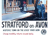
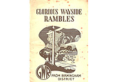
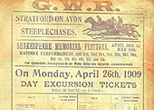
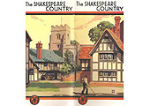
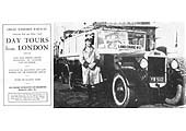
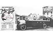
The GWR, as with all the railway companies, extensively
promoted places to visit by their railway services and Stratford upon Avon and
other areas within Warwickshire were no exception.
SHAKESPEARE LAND
Foreword from 'Great Western Railway ‘Shakespeare
Land – The World’s Great travel Shrine' (4th Edition April
1924).
back to
top
Stratford-on-Avon is universally regarded in the light of a
Travel Shrine of world-wide interest and importance. There are very few
travellers who arrive in England, either from the United States or our
Dominions beyond the seas, who do not hope to visit the birthplace of William
Shakespeare on the banks of the winding Avon, and the historic and picturesque
country of Warwickshire, before they leave these shores. The homeland of
Shakespeare has ever been, and always must be, regarded in the light of a place
of pilgrimage by every member of the great Anglo-Saxon race, and it is moreover
a scared spot, the key to the gates of which is firmly held by the Great
Western Railway. Whether travellers disembark at Plymouth, Liverpool, or
Bristol, it is by the Great Western Railway that they will make their journey
to Shakespeare’s land at once expeditious, agreeable, and inexpensive.
The same thing may be said when London happens to be the
pilgrims starting point and Shakespeare-land is approached through “Beechy
Bucks,” amongst the sylvan beauties of which William Penn lies buried. By
the aid of the Great Western Railway it is easy for the traveller to combine a
pilgrimage to the tomb of Shakespeare with a visit to either Oxford or Bath,
both of which places can claim American traditions and associations of the
highest interest. It should also be remembered that not far from
Shakespeare’s home stands another timbered sixteenth century house, in
which, during the later years of the reign of Queen Elizabeth, resided
Catherine Rogers, the fair daughter of a Stratford alderman, one of William
Shakespeare’s contemporaries, who became the wife of John Harvard of
Southwark, and whose son, called after his father, eventually gave his name to
the famous American University of Cambridge, Massachusetts.
Shakespeare’s house in Henley Street was acquired in
1847 by public subscription as a national memorial of the poet, and the
interesting timbered house close by, now used as a ticket office, was purchased
by Mr. Andrew Carnegie and has been vested in the Shakespeare trustees.
Pilgrims to Shakespeare-land may, with advantage, carefully study the latest
edition of ‘Stratford-on-Avon, from the earliest times to the death of
Shakespeare’ the admirable work of Sir Sidney Lee, one of the Shakespeare
trustees and the editor of the ‘Dictionary of National Biography’.
The unique facilities by rail and motor coach now afforded by the Great Western
Railway enable the traveller, whose time is precious, not only to explore
within the compass of a very few hours the historic sites and scenes of
Stratford-upon-Avon, but to include in his itinerary the mediaeval glories of
Warwick and Kenilworth Castles, and Royal Leamington Spa.
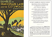
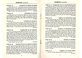
Rambles and Walking Tours in Shakespeare Land and the
Cotswolds
The Secretary of the North Finchley Rambling Club, Mr. Hugh
E. Page, wrote a series of rambling books for the Great Western Railway to
promote recreational walking from locations along the company’s lines.
These books were both popular enough and accurately informative to remain in
publication for many years after nationalisation. They reflect an era when this
burgeoning outdoor leisure pursuit was seen to offer an economic way to
appreciate the landscape and also a healthy form of exercise. The books include
advice on the rights and responsibilities of walkers and landowners in addition
to descriptions and details of the individual walks. The text associated with
each of the following images, are short extracts from Rambles and Walking Tours
in Shakespeare Land and the Cotswolds by Hugh E. Page. This was the third book
in the series published by the Great Western Railway in 1933.
Robert Ferris
|