|
|
 |
|
|
London North Western
Railway:
Midland
Railway:
Stratford
Midland Junction Railway
|
|
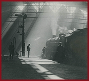
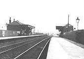
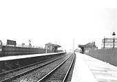
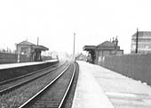
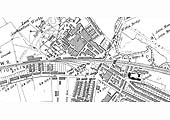
Witton Station
Witton station opened in two phases: to passengers on 1st
May 1876 and for goods in 1887. It was built by the LNWR on the former Grand
Junction Railway line which ran between Vauxhall, later Curzon Street, to the
original Wolverhampton station re-named Wednesfield Heath in 1855. The layout
of the station was the conventional two platform faces, opposite each other,
with the up and down main lines between them, Access to the station was via
Station Road which ran from Witton Lane and via two paths, one to each
platform, from Brookvale Road. On the Railway Clearing House (RCH) map - the
RCH was the organisation that managed the process of goods and passengers
travelling by two or more railway company's routes - the passenger station was
marked '(for Villa Grounds)'. This was the first reference to a sporting
activity associated with the station but in this instance it referred to the
cricket ground located adjacent to the Great Hall which itself was opposite
Staffordshire Pool and Aston Villa football club. Bob Essery writes in Part
One DJ Norton's pictorial survey of Railways in the West Midlands 'Witton
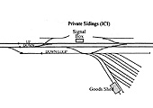
Station was not a blockpost; the signal post was opposite the goods station.
Witton was shown in timetables as "Witton for Aston Lower Grounds". These were
behind (north of) Aston Parish Church and were known as Serpentine Grounds
(this was a local, not railwayman's expression as the entrance was from
Serpentine Road)'.
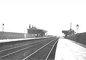
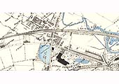
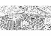
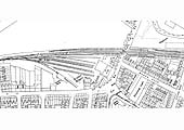
A goods yard, or wharf as its described on maps - this
reflected the use by early railways of canal terminology - was located on the
down side of the line sited to the Wolverhampton side of Witton station. The
sidings of the goods yard were connected via a loop line and held 225 wagons.
The Railway Clearing House Hand Book of Stations' notes that Witton, in
addition to handling passenger, parcels and goods facilities also provided
services for Furniture Vans, Carriages, Portable Engines and Machines on
Wheels. The Wharf also provided crane power capable of lifting up to twenty
tons. The station also serviced private sidings for Crawfords and ICI. The
following businesses are known to have used the wharf at one time or
another:
- Davis W. H. coal merchants
- Allen T. F. & Son, coal merchants
- Drury J. B. coal merchants
- Evans Wm. J. coal merchants
- Birmingham Co-operative Society Ltd coal merchants
- Barsons George. coal merchants
- Hamstead Officials Coal Company Ltd
- Lovell C. Shaw & Sons Ltd shipping agents
Ordnance Survey Maps and Schematic Drawing
|
|
|