·
LMS
·
GWR
·
LNER
·
Misc
·
Stations
·
What's New
·
Video
·
Guestbook
·
About
Donate
Facebook
Search
LMS Routes
London North Western Railway:
Rugby to Wolverhampton
Rugby to Leamington
Nuneaton to Leamington
Leamington to Weedon
Trent Valley Line
Birmingham New Street to Lichfield
Birmingham New Street to Harborne
Birmingham to Soho and Perry Barr
Midland Railway:
Nuneaton to Birmingham New Street
Birmingham New Street to Tamworth
Evesham to Birmingham
Hampton in Arden to Whitacre
Bournville to Birmingham New Street
Rugby to Leicester
Water Orton to Walsall
Halesowen to Northfield
Stratford Midland Junction Railway
The Shakespeare Route
LMS Route:
Rugby to Wolverhampton
LMS Route:
Nuneaton to Leamington
Maps of Coventry Station, Goods shed and yard
Coventry Station (291)
Locomotives seen at Coventry Station (140)
Maps, Plans and Drawings of Coventry station and its goods yard and shed
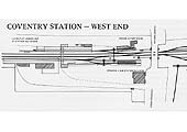
BRJ No 51 Article by Mike Christensen
Extracts from Binns & Clifford's Map of the L&BR updated by Wood of Rugby circa 1883
Ref: lnwrcov4486
Binns & Clifford and Wood
An updated 1841 map of the L&BR showing the junction with the Nuneaton branch and the entrance to the goods yard
Ref: lnwrcov4487
Binns & Clifford and Wood
An updated 1841 map of the L&BR showing Coventry station on the right and the goods yard on the left
Ref: lnwrcov4488
Binns & Clifford and Wood
An updated 1841 map of the L&BR giving a closer view of Coventry station and its Goods yard and shed
Ref: lnwrcov4488a
Binns & Clifford and Wood
An updated 1841 map of the L&BR giving a closer view of the goods yard, shed and railway houses
Ref: lnwrcov4488b
Binns & Clifford and Wood
An updated 1841 map of the L&BR giving a closer view of the station in both its earlier and later form
Ref: lnwrcov4489
Binns & Clifford and Wood
An updated 1841 map of the L&BR showing the station and the junction with the branch to Kenilworth
Ref: lnwrcov4507
Cambridge University Library
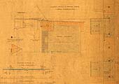
An 1863 LNWR Survey plan of the principal structures and layout of Coventry's second station built in 1840
Building Work Associated with the L&NWR
Ref: lnwrcov4491
L&NWR Society
An 1891 L&NWR plan showing the proposed footbridge from Spencer Park to Grovenor Road
Ref: lnwrcov4491a
L&NWR Society
Close up of the 1891 plan shows the footbridge crossed the L&BR lines and the sidings via two bridges
Ref: lnwrcov4491b
L&NWR Society
Close up of the 1891 plan showing the MR's goods shed at the top and the L&NWR shed at the bottom
Ref: lnwrcov4491c
L&NWR Society
Close up of the 1891 plan showing the station was fairly bereft of accommodation prior to the 1892-3 development
Ref: lnwrcov4491e
L&NWR Society
Notes on the 1891 LNWR plan of the new footbridge show the dates and names of recipients
Ref: lnwrcov4490
L&NWR Society
An 1891 drawing of the proposed layout of Coventry's goods yard with a new grain shed and offices
Ref: lnwrcov4490a
L&NWR Society
Close up of the 1891 drawing showing the line of the new footbridge, sidings and paved areas
Ref: lnwrcov4490b
L&NWR Society
Close up of the 1891 drawing showing the new grain shed in the centre, and the stables and offices on the right
Ref: lnwrcov4490d
L&NWR Society
Close up of the 1891drawing showing the stables & offices fronting on to Warwick Rd & Weighbridge on the right
Building Work Associated with the Midland Railway
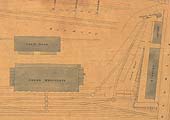
Ref: lnwrcov4495
L&NWR Society
A 1895 plan of the extension to MR's Goods Shed and Offices together with a horse and carriage landing
Ref: lnwrcov4495a
L&NWR Society
Close up of the 1895 plan showing the Goods Shed and Offices extensions built for the Midland Railway by the L&NWR
Ref: lnwrcov4495b
L&NWR Society
xxx
Ref: lnwrcov4497e
L&NWR Society
xxx
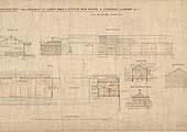
Ref: lnwrcov4496
L&NWR Society
Another 1897 drawing of the enlargement of the Midland Railway's Goods Shed and and Offices
Ref: lnwrcov4496a
L&NWR Society
xxx
Ref: lnwrcov4496b
L&NWR Society
xxx
Ref: lnwrcov4496c
L&NWR Society
xxx
Ref: lnwrcov4496d
L&NWR Society
xxx
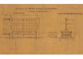
Ref: lnwrcov4497
L&NWR Society
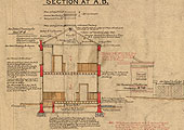
An 1897 drawing and plan showing details of the Midland Railway's new horse and carriage landing
Ref: lnwrcov4497a
L&NWR Society
xxx
Ref: lnwrcov4497b
L&NWR Society
xxx
Ref: lnwrcov4497c
L&NWR Society
xxx
Ref: lnwrcov4497d
L&NWR Society
xxx
Ref: lnwrcov4492
L&NWR Society
An 1891 L&NWR drawing of the existing footbridges which were to be removed as part of the yard's expansion
Ref: lnwrcov4492a
L&NWR Society
Close up showing a plan and side views of the two bridges to be removed as part of the expansion of the yard
Ref: lnwrcov4493
L&NWR Society
An 1893 drawing of the Office and Stable Block built as part of the expansion of Coventry's goods yard
Ref: lnwrcov4493a
L&NWR Society
xxx
Ref: lnwrcov4493b
Binns & Clifford and Wood
xxx
Ref: lnwrcov4493c
L&NWR Society
xxx
Ref: lnwrcov4493d
L&NWR Society
xxx
Ref: lnwrcov4493e
L&NWR Society
xxx
Ref: lnwrcov4494
L&NWR Society
An 1893 L&NWR drawing of details of the stables and office block built during the expansion of the yard
Ref: lnwrcov4494a
Binns & Clifford and Wood
xxx
Ref: lnwrcov4502
L&NWR Society
A 1902 plan of the station showing the new station buildings, luggage bridge and widened road overbridge
Ref: lnwrcov4502a
L&NWR Society
xxx
Ref: lnwrcov4502b
L&NWR Society
xxx
Ref: lnwrcov4498
L&NWR Society
A 1907 plan showing the revised layout of Coventry station and the proposed replacement footbridge
Ref: lnwrcov4498a
L&NWR Society
xxx
Ref: lnwrcov4498b
L&NWR Society
xxx
Ref: lnwrcov4498c
L&NWR Society
xxx
Ref: lnwrcov4499
L&NWR Society
An 1908 L&NWR drawing showing the alterations and additions to the station's buildings on the up platform
Ref: lnwrcov4499a
L&NWR Society
xxx
Ref: lnwrcov4499b
L&NWR Society
xxx
Ref: lnwrcov4499c
L&NWR Society
xxx
A L&NWR 1910 2-Chains to the Mile Plan
Ref: lnwrcov4083
L&NWR
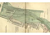
A 1910 2-Chain to the Mile Plan of Coventry to Nuneaton branch featuring Coventry Station and Goods Yard
Ref: lnwrcov4152
L&NWR
A 1910 2-Chain to the Mile L&NWR Plan showing the layout of the main portions of Coventry station
Ref: lnwrcov4152a
L&NWR
Close up of the 2-Chain to the Mile L&NWR Plan showing the names of the rooms on the up and down platforms
Ref: lnwrcov4153
L&NWR
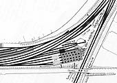
A 2-Chain to the Mile L&NWR Plan showing the extent of the Goods yard and the layout of Nuneaton Junction
Ref: lnwrcov4153a
L&NWR
Close up of the 1910 2-Chain to the Mile L&NWR Plan showing the goods sheds, cranes, landing and sidings
Ref: lnwrcov4153b
L&NWR
Close up of the Plan showing the layout of the junction of the Nuneaton branch including No 4 Signal Cabin
Ref: lnwrcov4153c
L&NWR
Close up of the 2-Chain Plan showing the sidings leading to Coventry Cattle Market and the Coal Wharf
Ref: lnwrcov4153d
L&NWR
Close up of the 2-Chain Plan of the layout of the sidings, wagon turntables and cranes in the goods yard
Schematic Diagrams of Coventry Station, Goods Yard and Shed published prior to 1900
Coventry station and shed
Ref: lnwrcov2768
Ordnance Survey
Layout of the station prior to the 1901-4 building work with Eaton road and the main entrance at the bottom
Ref: lnwrcov2768a
Ordnance Survey
Part of the OS map showing the different lengths of platforms and the junction with Leamington branch
Ref: lnwrcov2768b
Ordnance Survey
Part of the Ordnance Survey map showing the private road in front of the station and the tram terminus in Eaton Road
Ref: lnwrcov2767
Ordnance Survey
Layout of Coventry Shed in 1920 showing the original 42 foot turntable being accessed direct from the coaling road
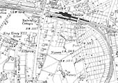
Ref: lnwrar3256
National Library of Scotland
Ordnance Survey map showing goods yard, station & shed first surveyed in 1887 and published in 1888
Ref: lnwrcov4357
L&NWR
An 1882 Map of the East end of Coventry station showing the second, Webb designed, two road shed
Ref: lnwrcov4355
L&NWR
An 1840s plan of the original and newly rebuilt Coventry Station and the sidings and goods warehouse
Ref: lnwrcov4361
LMSR
An LMS Schematic showing Coventry No 1 Signal Cabin's track layout of the junction with the Leamington branch
Ref: lnwrcov4375
LMSR
An LMS Schematic diagram showing Coventry No 2 Signal Cabin's track layout of the parcel dock and goods sidings
Ref: lnwrcov4378
HF Wheeler
An LMS Schematic diagram of Coventry No 3 Signal Cabin's track layout with the Nuneaton branch and sidings
Map of the goods yard and northern approaches
Ref: lnwrcov2769
Ordnance Survey
Ordnance Survey map showing Coventry's extensive goods yard and the junction with the Nuneaton branch
Ref: lnwrcov2769a
Ordnance Survey
Part of the Ordnance Survey map showing Coventry Goods yard and the two LNWR sheds and the joint MR/LNWR shed
Ref: lnwrcov2769b
Ordnance Survey
Part of the OS map showing the Nuneaton branch junction, the sidings and roads leading to the the goods sheds
Ref: lnwrcov2763
Ordnance Survey
Part of the Ordnance Survey map showing the entrance to the goods yard off the Nuneaton branch
Map of the goods yard and northern approaches
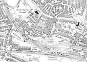
Ref: lnwrcov3260
National Library of Scotland
OS map showing Coventry Goods Yard, Station and Shed which revised in 1903 and published in 1906
Ref: lnwrcov3254
National Library of Scotland
OS map showing Coventry Station & Shed which was revised in 1912 but not published until circa 191
Ref: lnwrcov3252
National Library of Scotland
OS map showing Coventry Station & Shed which was revised in 1923 but published circa 1926
Ref: lnwrcov3250
National Library of Scotland
Ordnance Survey map showing Coventry Station & Shed which was revised in 1938 but published 1944
Ref: lnwrcov3248
National Library of Scotland
Ordnance Survey Map Revised 1938 Published circa 1947 showing Coventry Station & Shed
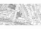
Ref: lnwrcov3256
National Library of Scotland
Ordnance Survey map showing goods yard, station & shed first surveyed in 1887 and published in 1888
Ref: lnwrcov3257
National Library of Scotland
OS map showing Coventry Goods Yard & Albany Road as first surveyed in 1887 and published in 1888
Ref: lnwrcov3259
National Library of Scotland
OS map showing Coventry Goods Yard & Albany Road which was revised in 1903 and published in 1906
Ref: lnwrcov3260
National Library of Scotland
OS map showing Coventry Goods Yard, Station and Shed which revised in 1903 and published in 1906
Ref: lnwrcov3255
National Library of Scotland
OS map showing Coventry Goods Yard & Albany Road which was revised in 1912 and published circa 1919
Ref: lnwrcov3253
National Library of Scotland
OS map showing Coventry Goods Yard & Albany Road which was revised in 1923 but published circa 1926
Ref: lnwrcov3251
National Library of Scotland
OS map showing Coventry Goods Yard & Albany Road which was revised in 1938 but published 1944
Ref: lnwrcov3249
National Library of Scotland
Ordnance Survey map revised in 1938 but published circa 1947 showing Coventry Goods Yard & Albany Road
Ordnance Survey Maps 25 Inch to the Mile Scale
Maps showing Station and Goods Yard immediately either side of Warwick Road
Ref: lnwrcov3729
National Library of Scotland
An 1887 25 inches to the mile Ordnance Survey map of the goods yard and station either side of Warwick Road
Ref: lnwrcov3729a
National Library of Scotland
Close up of the 1887 OS map showing the sidings and cattle docks adjacent to the entrance from Warwick Road
Ref: lnwrcov3739
National Library of Scotland
A 1903 25 inches to the mile Ordnance Survey map of the goods yard and station either side of Warwick Road
Ref: lnwrcov3740
National Library of Scotland
A 1912 25 inches to the mile Ordnance Survey map of the goods yard and station either side of Warwick Road
Maps showing Goods Yard and the Junction with the Nuneaton Line
Ref: lnwrcov3736
National Library of Scotland
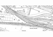
A 1903 25 inches to the mile OS map of the junction with the Nuneaton branch line and entrance to the goods yard
Ref: lnwrcov3737
National Library of Scotland
A 1912 25 inches to the mile OS map of the junction with the Nuneaton branch line and entrance to the goods yard
Ref: lnwrcov3738
National Library of Scotland
A 1937 25 inches to the mile OS map of the junction with the Nuneaton branch line and entrance to the goods yard
back to top
Coventry Station (291)
Locomotives seen at Coventry Station (140)
Maps, Plans and Drawings of Coventry station and its goods yard and shed
BRJ No 51 Article by Mike Christensen