·
LMS
·
GWR
·
LNER
·
Misc
·
Stations
·
What's New
·
Video
·
Guestbook
·
About
Donate
Facebook
Search
LMS Routes
London North Western Railway:
Rugby to Wolverhampton
Rugby to Leamington
Rugby to Market Harborough
Nuneaton to Leamington
Coventry Loop Line
Leamington to Weedon
Trent Valley Line
Birmingham New Street to Lichfield
Birmingham New Street to Harborne
Birmingham-Soho-
Perry Barr-Birmingham
Midland Railway:
Nuneaton to Birmingham New Street
Birmingham New Street to Tamworth
Evesham to Birmingham
Hampton in Arden to Whitacre
Birmingham West Suburban Railway
Rugby to Leicester
Water Orton to Walsall
Halesowen to Northfield
Stratford Midland Junction Railway
The Shakespeare Route
LMS Route:
Nuneaton to Leamington
LMS Route:
Rugby to Leamington
LMS Route:
Leamington to Weedon
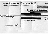
Warwick (Milverton) Station (34)
Warwick (Milverton) Goods Yard (26)
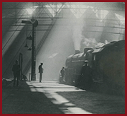
Warwick (Milverton) Shed (47)
Warwick (Milverton): Goods Shed and Yard
Ref: - lnwrwar_stn2006
Warwick Museum
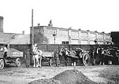
Horse-drawn and motorised road transport operated by coal merchants, Nadin & Co of Regent Street, Leamington
Ref: - lnwrwar_stn2010
D Churchill
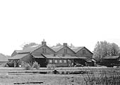
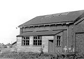
A long distance view of Warwick Milverton's goods shed as seen from Old Milverton Road in May 1972
Ref: - lnwrwar_stn2007
D Churchill
View of the north end of the shed showing where the rails used to enter the shed via the door on the left
Ref: - lnwrwar_stn2008
D Churchill
The north west corner of the goods shed showing the door in the centre which was used for road vehicles
Ref: - lnwrwar_stn2016
D Churchill
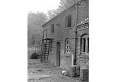
Another view of the two-storey building and the iron staircase used to access the hay loft on the upper floor
Ref: - lnwrwar_stn2018
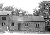
D Churchill
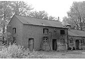
View of Milverton's stable block located on the south side of the goods yard backing on to Rugby Road
Ref: - lnwrwar_stn2017
D Churchill
Close up of the two-storey section of the stable block and the staircase providing access to the upper floor
Ref: - lnwrwar_stn2019
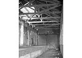
D Churchill
An interior view of Milverton goods shed showing the platform used to tranship goods between rail and road
Ref: - lnwrwar_stn2020
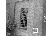
D Churchill
Detail of one of the eight window frames that were to be seen along the shed wall adjacent to the internal track
Ref: - lnwrwar_stn2021
D Churchill
View from the north-east of the side elevation of Milverton goods shed which faced on to the main line
Ref: - lnwrwar_stn2022
D Churchill
Close up showing the single storey section of Milverton's stable block and its ventilation shaft
Ref: - lnwrwar_stn2012
D Churchill
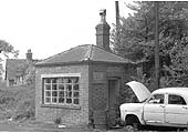
The weighbridge office at the entrance to the goods yard near the junction of Rugby Road and Old Milverton Road
Ref: - lnwrwar_stn2011
D Churchill
View of Milverton Goods weighbridge office from within the yard looking towards Rugby Road in May 1972
Ref: - lnwrwar_stn2350
D Churchill
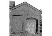
View of the door to the rail entrance located in the south elevation of Milverton goods shed seen in May 1972
Ref: - lnwrwar_stn2351
D Churchill
Part view of the south end of Milverton's goods shed showing the timber lean-to office extension
Ref: - lnwrwar_stn4041
D Churchill
View of the north end corner of the shed showing where the rails used to enter the shed via the door on the left
Ordnance Survey Maps
Ref: - lnwrwar_shed4040b
RJS
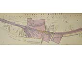
View of the 1845 plan showing on the right the original terminus station used for both arrivals and departure
Ref: lnwrwar_shed4035
National Library of Scotland
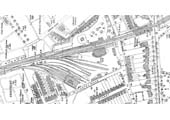
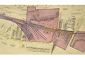
A 1923 Ordnance Survey Map showing Warwick Shed, Milverton Goods Shed and Milverton Station on the far right
Ref: lnwrwar_shed4036
National Library of Scotland
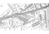
A 1903 Ordnance Survey Map showing Warwick Shed, Milverton Goods Shed and Milverton Station on the far right
Ref: lnwrwar_shed4037
National Library of Scotland
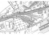
A 1903 25 inch to the Mile OS Map showing Warwick Shed on the left and Milverton Goods Shed on the far right
Ref: lnwrwar_shed4038
National Library of Scotland
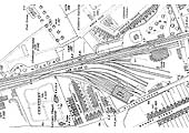
A 1923 25 inch to the Mile OS Map showing Warwick Shed on the left and Milverton Goods Shed on the far right
Ref: lnwrwm1
British Railways
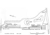
A British Railways 1:1250 Scale Map of the approaches to Warwick Milverton station, the goods yard and shed in 1952
Ref: lnwrwm1a
British Railways
A British Railways 1:1250 Scale Map of Warwick Milverton station, the goods yard and shed in 1952
Ref: lnwr_track3370
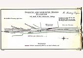
B Hickman
LNWR trackplan of GF Smith & Sons' Brickworks siding at Milverton on the Nuneaton to Leamington line
Ref: lnwrmap104
M Hollick
A 1930s LMS Control strip map showing the goods shed and sidings adjacent to Warwick Milverton station
Ref: lnwrmap110
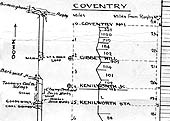
M Hollick
A 1930s LMS Control strip map showing the route between Coventry No 1 signal box and Leamington Avenue
Warwick (Milverton) Station (37)
Warwick (Milverton) Goods Yard (26)
Warwick (Milverton) Shed (41)