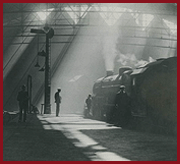
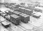
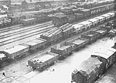
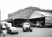
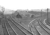
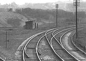
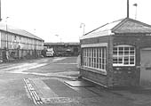
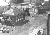
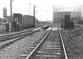
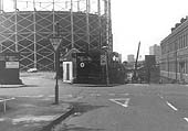
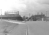
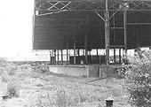
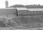
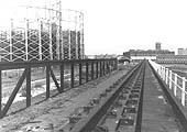
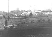
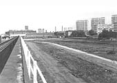
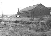
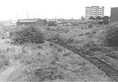
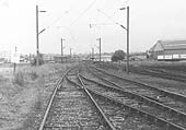
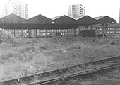
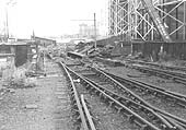
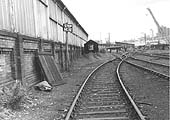
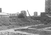
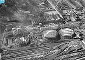
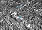
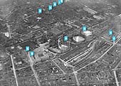
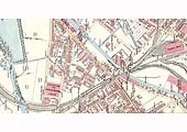
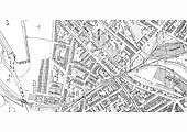
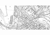
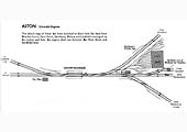
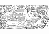
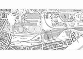
·  LMS  ·  GWR  ·  LNER  ·  Misc  ·  Stations  ·  What's New  ·  Video  ·  Guestbook  ·  About

LMS Route: Birmingham New Street to Lichfield
LMS Route: Birmingham - Soho Road - Perry Barr - Birmingham

Aston Station (26) Aston Shed (62) Windsor Street Goods Station (35) Memories of Aston Shed

Windsor Street Goods Station & Wharf

Windsor Street Goods Station and Wharf was opened on 1st March 1880 by the LNWR and was located approximately one mile from the centre of Birmingham. The facilities were located at the end of a long branch line which commenced from the junction at Aston station on the former Grand Junction Railway route to Birmingham. The route of the branch was for a large part dictated by the availability of unoccupied land in a built up area. It was required because the existing facilities at Curzon Street were no longer sufficient to meet the needs of Birmingham's fast growing economy. In addition, the opening of the line from Aston to Stechford on the Birmingham to Coventry line helped to generate more traffic. The goods yard needed to be as near to the centre of Birmingham as possible to in order to compete effectively with the Great Western Railway's and, in particular, the Midland Railway's central locations. In September 1901, Clinker notes in his book 'Railways of the West Midlands 1808 - 1954' published by the Stephenson Locomotive Society, that 'a new large warehouse was brought into use', the reader should note that its this warehouse which is seen in the two Edwardian photos and Ordnance Survey maps provided below.

The goods facilities were divided into two parts, a transit facility provided under cover known as Aston Goods and an open yard with over head cranage facilities to handle mineral and other non perishable items in an area known as Windsor Street Wharf, the latter accommodating a smaller goods shed from before 1902. The site was bounded on one side by by Rupert Street, with Rocky Lane at one end and Proctor Street at the other end with Avenue Road dissecting the site. The fourth side was bounded in part by an open area to between Rocky Lane and Avenue Road and by Birmingham Corporation's Windsor Street Gas works between Avenue Road and Proctor Street. Entrance to each portion was at the junction of Rupert Street and Avenue Road, each entrance being on the same side of Rupert Street but opposite each other on Avenue Road. See images 'lnwra3270' and 'lnwra3632' for the 1903 and 1913 Ordnance Survey maps of the site.

The Goods Station, was located between Rocky Lane and Avenue Road and was a dedicated goods shed with stabling in front of the shed for wagons to be loaded and unloaded. This covered area allowed both perishable and valuable items to be transhipped safely and quickly. Half of the sidings located at the front of the shed terminated at the wagon turntable at the front of the shed, being used to release wagons for outward movement. Non powered or 'dumb' capstans were also provided either side of the wagon turntables. This allowed the horses to rotate the wagons by using ropes wrapped around one or more capstans to ease their movement into and out of the shed. This facility saved having to move all of the wagons stabled on the siding. This section of the site also included an end-on loading dock for road vehicles. There was also a large underground bonded warehouse, a common feature at many large railway goods stations. The bonded warehouse allowed dutiable goods to be stored without payment of duty until the product was sold to their customer. The Goods Shed has cranage power capable of lifting loads of up to twenty tons. The company had to post a customs bond Custom and Excise.

Windsor Street Wharf, was located behind the shed and across Avenue Road being accessed via a rail overbridge. The Wharf accommodated two travelling over head cranes for the handling of large loads such as the timber logs seen in image 'lnwra3633' and containers, furniture vans, etc. By the time the yard had been fully developed, the sidings were capable of holding some three hundred and thirty-four wagons. The adjacent Gas Works had an internal railway system for the movement of materials which was accessed from the rail link to the Wharf as it crossed Avenue Road bridge. By 1902 the Wharf had only six sidings, only four of which could be used for loading/unloading. By 1913 the only addition to the Wharf was the second travelling crane (both travelling cranes were capable of lifting loads of up to ten tons), its associated siding and the storage sidings north of Rocky Lane bridge. Between 1913 and 1938 a lot more sidings were installed (as seen in image 'lnwra3673) including the covered platforms north of the warehouse at the Rupert Street side. The entrance to the Wharf also accommodated a weighbridge and office. Adjacent to the Goods Station's entrance was a block of offices and stables which ran parallel with Avenue Road and in all probability were erected at the same time as the new large warehouse was brought into use in 1901. During its LMS ownership, on 18th October 1940, both the Goods Yard and Windsor Street Gas Works were significantly damage during a German air raid on the city.

Our thanks to Reg Instone of the LNWR Society for help providing some of the above information.

A 1903 view of the sidings looking North East which were located in front of Windsor Street Goods Station
Ref: lnwra3641
HMRS
A 1903 view of the sidings looking North East which were located in front of Windsor Street Goods Station
A 1903 view of the sidings in front of Windsor Street Goods Station showing a wide variety of loads
Ref: lnwra3633
HMRS
A 1903 view of the sidings in front of the Goods depot and the lines to the Wharf at the rear of the yard
A 1970 view of the loading dock to Windsor Street goods station which was built by the LNWR in 1901
Ref: lnwra3268
Aucklander
A 1970 view of the loading dock to Windsor Street goods station which was built by the LNWR in 1901
View from Aston No 1 signal cabin towards Vauxhall and Duddeston with the branch to Windsor Street on the right
Ref: lnwra2309
DJ Norton
View from Aston No 1 signal cabin towards Vauxhall and Duddeston with the branch to Windsor Street on the right
Close up showing the branch line curving away to former LNWR Windsor Street Goods station
Ref: lnwra2309b
DJ Norton
Close up showing the branch line curving away to the former LNWR Windsor Street Goods station & wharf

Demolition of Windsor Street Goods Station and Wharf

Mike Westley's 1979 photos of Windsor Street Goods Station and Wharf are from Geograph collection © and licensed for reuse under this Creative Commons Licence.

View of the former weighbridge and office at the road entrance to the goods station off Rupert Street
Ref: lnwra3654
M Westley
View of the former weighbridge and office at the road entrance to the goods station off Rupert Street
A rear view of the former weighbridge and office at the road entrance to the goods station off Rupert Street
Ref: lnwra3671
M Westley
Rear view of the former weighbridge and office at the road entrance to the goods station off Rupert Street
Looking across Rocky Lane overbridge towards the Gas Works with one of the three gas holders on the right
Ref: lnwra3664
M Westley
Looking across Rocky Lane overbridge towards the Gas Works with one of the three gas holders on the right
On the left is the entrance to Windsor Street Wharf whilst on the right is the rail bridge over Avenue Road
Ref: lnwra3665
M Westley
On the left is the entrance to Windsor Street Wharf whilst on the right is the rail bridge over Avenue Road
Looking towards the Gas Works near the junction of Rupert Street and Walter Street
Ref: lnwra3672
M Westley
Looking towards the Gas Works near the junction of Rupert Street and Walter Street

The front of the former goods station with the platforms for moving the loads from the railway wagons on the right
Ref: lnwra3656
M Westley
The front of the former goods station with the platforms for moving the loads from the railway wagons on the right
View of two buildings within the goods yard, the rear one being the original Goods Station
Ref: lnwra3657
M Westley
View of two buildings within the goods yard, the rear one being the original Goods Station
View from the top of one of the two former travelling cranes located in Windsor Street Wharf
Ref: lnwra3658
M Westley
View from the top of one of the two former travelling cranes located in Windsor Street Wharf
View from inside the former platforms looking west across the lines to the Birmingham & Fazeley Canal
Ref: lnwra3659
M Westley
View from inside the former platforms looking west across the lines to the Birmingham & Fazeley Canal
View from the top former travelling crane towards the entrance on corner of Rupert Street and Avenue Road
Ref: lnwra3660
M Westley
View from the top former travelling crane towards the entrance on corner of Rupert Street and Avenue Road

Part of the track running in front of the goods buildings near to Rocky Lane and Rupert Street junction
Ref: lnwra3661
M Westley
Part of the track running in front of the goods buildings near to Rocky Lane and Rupert Street junction
Looking alongside Rupert Street towards Avenue Road with the entrance to the Wharf in the corner on the right
Ref: lnwra3662
M Westley
Looking alongside Rupert Street towards Avenue Road with the entrance to the Wharf in the corner
Looking up a slight incline in direction of Rocky Lane with the Cooling Towers at Heartlands Parkway in the distance
Ref: lnwra3663
M Westley
Looking up in the direction of Rocky Lane with the Cooling Towers at Heartlands Parkway in the distance
Looking north from Rocky Lane road bridge towards the former junction south of Aston Station
Ref: lnwra3666
M Westley
Looking north from Rocky Lane road bridge towards the former junction south of Aston Station
Covered former goods platforms running parallel to Rupert Street and behind that 3 high blocks of flats on Cornwall Street
Ref: lnwra3667
M Westley
Covered former goods platforms running parallel to Rupert St and behind that the flats on Cornwall St

Looking south-west across Avenue Road bridge towards Proctor Street with the two gasometers on the right
Ref: lnwra3668
M Westley
Looking south-west across Avenue Road bridge towards Proctor Street with the two gasometers on the right
Looking alongside the goods building towards Avenue Road bridge which is currently being dismantled
Ref: lnwra3669
M Westley
Looking alongside the goods building towards Avenue Road bridge which is currently being dismantled
Looking back along the sidings adjacent to the goods building towards Rocky Lane bridge and Aston station
Ref: lnwra3670
M Westley
Looking back along the sidings adjacent to the goods building towards Rocky Lane bridge and Aston station
View south towards Avenue Road and Rupert Street, where a crane is dismantling the bridge
Ref: lnwra3655
M Westley
View south towards Avenue Road and Rupert Street, where a crane is dismantling the bridge

Photographs of Windsor Street Wharf by Britain From Above

Another 1938 aerial view of the Wharf showing another, smaller, goods shed and the extensive sidings
Ref: lnwra3673
Britain From Above
Another 1938 aerial view of the Wharf showing another, smaller, goods shed and the extensive sidings
A 1933 aerial view looking towards the city centre with the Wharf and Gas Works in the foreground
Ref: lnwra3674
Britain From Above
A 1933 aerial view looking towards the city centre with the Wharf and Gas Works in the foreground
A 1938 overhead view of Windsor Street Gas Works and the extensive sidings of the Wharf
Ref: lnwra3675
Britain From Above
A 1938 overhead view of Windsor Street Gas Works and the extensive sidings of the Wharf
A 1938 aerial view showing Windsor Street Wharf alongside a camouflaged Gas Works
Ref: lnwra3676
Britain From Above
A 1938 aerial view showing Windsor Street Wharf alongside a camouflaged Gas Works

Ordnance Survey Maps and Schematics of Aston station and junctions

An 1886 OS map of Aston with lines to Lichfield, Walsall, Stechford, New Street and Windsor Street Goods Depot
Ref: lnwra3269
National Library of Scotland
An 1886 OS map of Aston with lines to Lichfield, Walsall, Stechford, New Street and Windsor Street Goods Depot
A 1902 OS map of Aston with lines to Lichfield, Walsall, Stechford, New Street and Windsor Street Goods Depot
Ref: lnwra3272
National Library of Scotland
A 1902 OS map of Aston with lines to Lichfield, Walsall, Stechford, New Street and Windsor Street Goods Depot
An 1886 OS map of Aston with lines to Lichfield, Walsall, Stechford, New Street and Windsor Street Goods Depot
Ref: lnwra3271
National Library of Scotland
A 1913 OS map of Aston with lines to Lichfield, Walsall, Stechford, New Street and Windsor Street Goods Depot
Schematic showing the track layout of Aston station and shed with lines to Lichfield, Stechford and New Street
Ref: lnwra2303
J Copsey
Schematic showing the track layout of Aston station and shed with lines to Lichfield, Stechford and New Street
Schematic showing the lines between Aston and Curzon street with the branch to Windsor Street Goods station
Ref: lnwra2312
J Copsey
Schematic showing the lines between Aston and Curzon street with the branch to Windsor Street Goods station

Ordnance Survey Maps of Windsor Street Goods Station and Wharf

A 1902 Ordnance Survey Map showing the layout of Windsor Street Goods Station and Wharf
Ref: lnwra3270
National Library of Scotland
A 1902 Ordnance Survey Map showing the layout of Windsor Street Goods Station and Wharf
A 1913 Ordnance Survey Map showing the layout of Windsor Street Goods Station and Wharf
Ref: lnwra3632
National Library of Scotland
A 1913 Ordnance Survey Map showing the layout of Windsor Street Goods Station and Wharf

Aston Station (26) Aston Shed (62) Windsor Street Goods Station (35) Memories of Aston Shed